CarpatDome builds scalable passive-RF drone detection on NATO's eastern flank: a dense mesh of COTS receivers that hears drones without emitting a single watt.
It is a sensing layer, designed to densify radar, EO/IR and existing C2 — not to replace them.
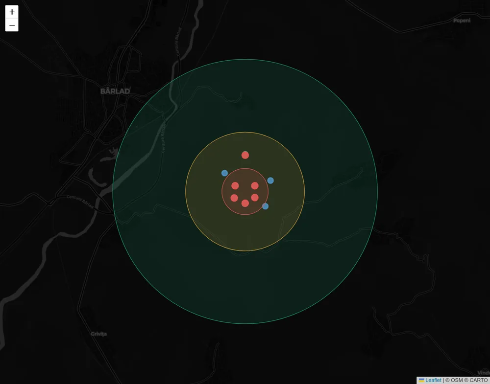
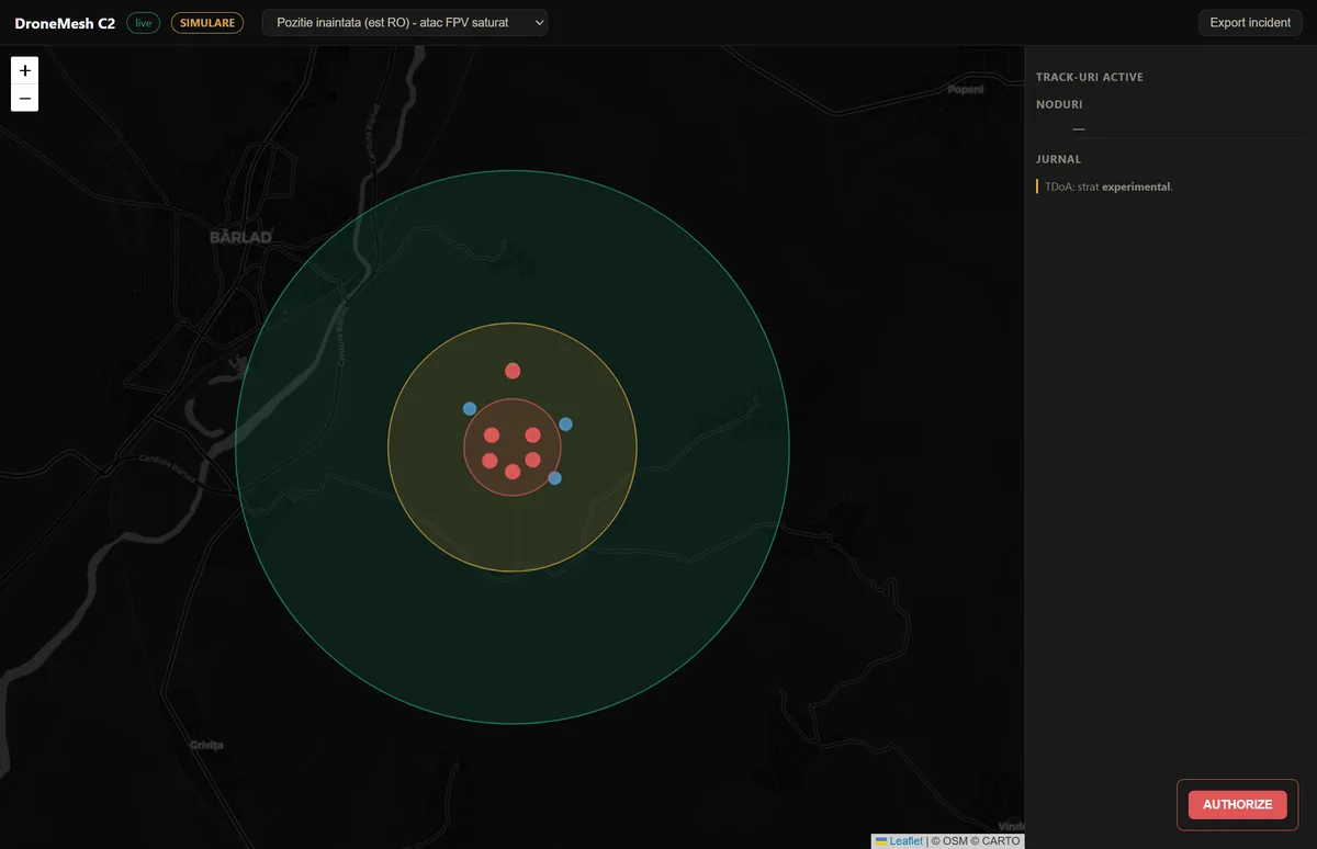
Scripted scenario fpv-saturation-defense, replayed from the v1.1 software demonstrator onto the C2 radar map. Synthetic track data — no live-hardware detection has been performed.
Status
Where the programme actually is.
Stated plainly, because a partner finding this out later costs more than reading it now.
CarpatDome programme status by milestone, as of 15 September 2026
Milestone
State
Software demonstrator (v1.1, extended 7 September 2026)
Complete — node runtime, acoustic layer, integration port
Physical receiver node
Components received — assembly not started
Acoustic layer (RF-silent drones)
Software only — synthetic audio, no field capture
Multi-node TDoA localisation
Experimental — end-to-end in software, synthetic IQ only
The receive-only sensing chain does exactly one thing: listen. No transmitter, no emitted power, no RF signature from the receivers themselves. Backhaul from node to fusion is deployment-dependent and can be wired for fully RF-silent operation. No transmit-side spectrum allocation is required by the sensing subsystem.
RECEIVE-ONLY SENSING CHAIN.
Density, not replacement.
A radar covers one site well. A mesh of COTS receivers covers a region for a fraction of the cost per covered km² — and sees a class of signal radar does not: the drone's own emissions. CarpatDome densifies a layered air picture alongside radar and EO/IR.
4 LOGICAL NODES IN THE SOFTWARE DEMONSTRATOR.
A working demonstrator, not slideware.
Remote ID decoding (Wi-Fi and Bluetooth, including Long Range), sub-GHz RF scanning, an acoustic layer for RF-silent drones and multi-node fusion run end-to-end in software; 192 of 194 automated tests pass, the two excluded needing a physical radio and a running broker. Every source fuses into one contact per drone with a confidence score. TDoA runs on synthetic IQ — an experimental research layer. The engagement ladder (detect → track → identify → warn → authorize → intercept) is a scripted C2 simulation: CarpatDome contains no effector.
192 OF 194 AUTOMATED TESTS PASS · 14 SCENARIOS.
Architecture
How it works
Nodes.
Each node runs one process per sensor: passive Remote ID / OpenDroneID decoding (Wi-Fi and Bluetooth Long Range), sub-GHz RF energy scanning via RTL-SDR, an acoustic listener and a time-stamped IQ capture for TDoA. Receive-only: the sensing chain has no transmitter. The demonstrator runs 4 logical nodes; physical nodes: components received, assembly not started.
MQTT.
Nodes publish over MQTT using versioned JSON contracts — every message carries a schema id, a node id and a timestamp, so an integrator knows exactly what they're consuming and when the contract changes. The transport link itself is deployment-dependent: wire it, and the deployment stays radio-silent end to end.
Fusion.
A central service deduplicates detections, associates tracks across nodes and fuses every source — Remote ID, RF, acoustic, TDoA and partner sensors — into one contact per drone with a confidence score. TDoA cross-correlation and multilateration run here end-to-end on synthetic IQ — an experimental research layer, not a validated capability.
C2 radar UI.
A live radar map (WebSocket-driven) shows tracks and node health and, in demo scenarios, replays a scripted engagement flow: detect → track → identify → warn → authorize → intercept.
Four sensing modes — they are not interchangeable
Cooperative — Remote ID / OpenDroneID.
Decodes the identification beacon a compliant drone broadcasts by regulation. Strong for airspace awareness, careless or unauthorised civilian UAS, attribution, and friend/known/unknown differentiation. It does not detect an adversary who chooses not to broadcast.
Non-cooperative — RF energy.
Spectrum activity detection and signal classification, independent of any cooperation from the target. This is the layer that has to carry the adversarial case — and the layer with the most field characterisation still ahead of it.
Acoustic — RF-silent drones.
Harmonic signature detection, class and bearing from a microphone array. Gives a direction, not a position — the layer that has to carry the drone that emits nothing. Software-tested on synthetic audio only; no field capture yet.
Experimental localisation — TDoA.
Cross-node time-difference correlation and multilateration. Runs today on synthetic IQ only, unvalidated against ground truth.
Band coverage — what the current receiver chain can and cannot hear
Published rather than left for a reader to assume. The current sub-GHz chain is built on RTL-SDR, which tops out well below the 2.4/5.8 GHz bands most FPV links use. That is a scope boundary, not an oversight — closing it requires a different receiver, and we would rather state the gap than have an RF engineer find it. This bears directly on the FPV scenarios shown below: a drone whose video and control links sit on 5.8 GHz is not audible to the current sub-GHz chain, so those scenarios model a receiver chain the present one does not yet match.
Receiver chain coverage by frequency band, mechanism and current status
Band
Mechanism
Status
24 MHz – 1.77 GHz
RTL-SDR energy scan and signal classification
Implemented in software; bench tier
2.4 / 5.8 GHz
Remote ID beacon decode — Wi-Fi in monitor mode and Bluetooth Long Range
Software complete; receiver hardware received, not assembled
2.4 / 5.8 GHz
Analogue and digital FPV video / control links (wideband SDR)
Not covered by the current receiver chain
The acoustic layer is not an RF band and is listed separately: it hears the airframe, not the radio.
What CarpatDome is not
CarpatDome is a sensing and C2-integration layer. It contains no effector — no jammer, no spoofer, no take-over capability. Those are out of scope legally and technically; the system is receive-only. The warn → authorize → intercept stages in the demonstrator are a scripted C2 workflow with interceptor kinematics rendered in the UI. No hardware is commanded, and none exists.
Open by design
CarpatDome is built as a sensor layer, not a closed C-UAS appliance. Detections and tracks are exposed over MQTT with versioned JSON contracts, plus REST and WebSocket, so a third-party C2 or sensor-fusion environment can consume the feed and know exactly when a contract changes.
The same versioned contract works in both directions: a partner radar or EO/IR sensor publishes detections into the fused picture, and the C2 emits provider-neutral cues to any downstream consumer. No device-specific code on our side — a partner's sensor or effector connects at this boundary.
Demonstrator security tier. The demonstrator runs on an isolated network. Authenticated transport, role separation and an audit log are the production tier — scoped, not built.
Proof
See the demonstrator, not a claim about it.
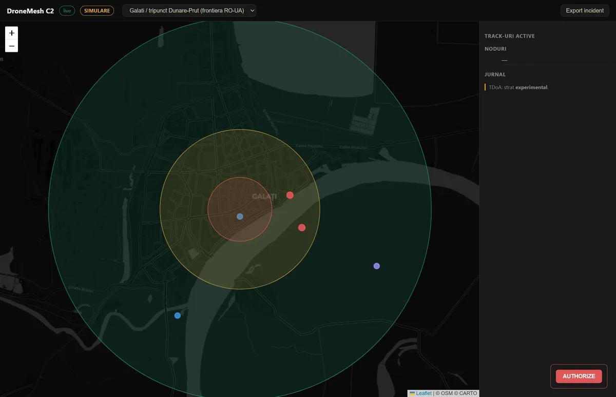
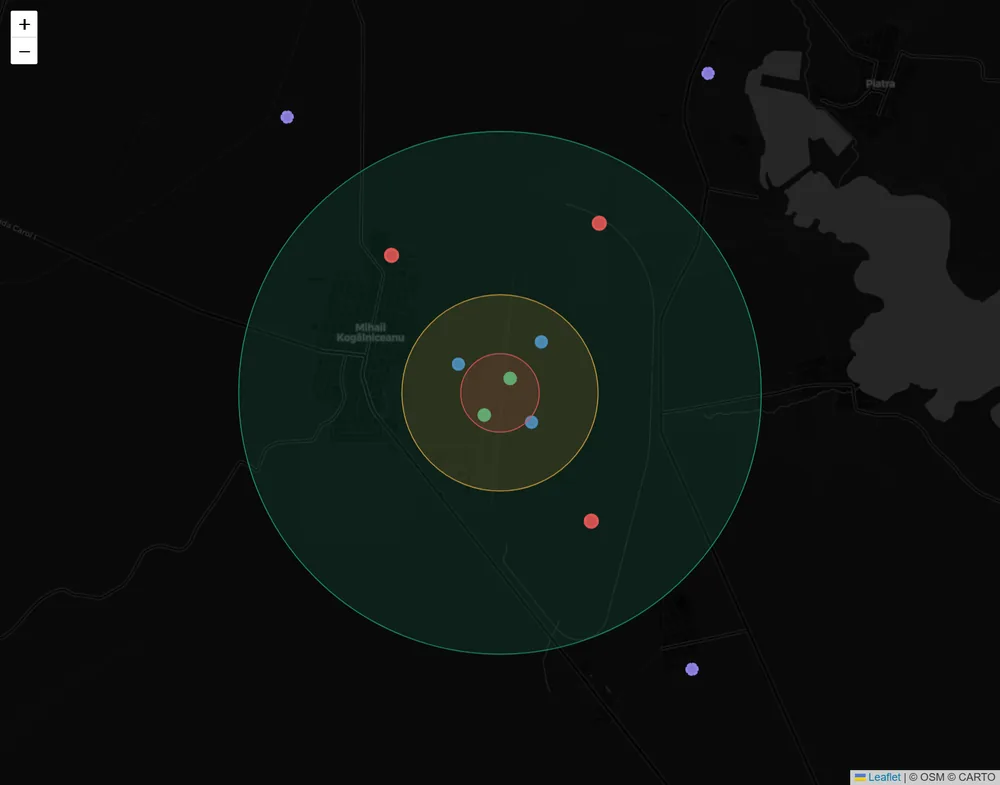
SimulatedGalați · Danube–Prut tripoint (RO–UA border)SimulatedForward position · saturated FPV attackSimulatedM. Kogălniceanu air base · swarm raid
14 demonstrative scenarios, chosen for geographic and threat-model coverage across Romania and the eastern NATO flank — from a Danube border crossing to a saturated FPV attack on a forward position to critical-infrastructure reconnaissance:
All scenarios are synthetic demonstrations built on publicly available geographic context. They are not deployments, endorsements, threat assessments, or statements of any relationship with the depicted sites or their operators. No scenario contains or reflects real detection data. Several — the FPV scenarios in particular — assume 2.4/5.8 GHz coverage the current receiver chain does not have; see band coverage above.
Simulatedgalati-danube-border — scripted scenario replay, synthetic data
Pick a scenario below to replay it. Every clip is rendered from the demonstrator's declarative scenario files — synthetic tracks, a SIMULATION badge, and kinematic intercept simulation where the scenario authorizes engagement. No live-hardware detection.
Scenario
Site
galati-danube-border
Galați / Danube–Prut tripoint (RO–UA border)
fpv-saturation-defense
Forward position (eastern RO) — saturated FPV attack
front-counter-isr
Forward observation post — counter-ISR
cernavoda-dark-recon
Cernavodă nuclear power plant
deveselu-loiter
Deveselu Aegis Ashore site
kogalniceanu-swarm-raid
Mihail Kogălniceanu air base
otopeni-careless-rid
Otopeni international airport
constanta-port-recon
Port of Constanța
substation-sabotage
400kV Transelectrica substation
ploiesti-fpv-attack
Petrobrazi refinery
tulcea-border-transit
Tulcea / Plauru border
arena-event-shield
Arena Națională stadium
jilava-contraband
Jilava penitentiary
five-node-correction
Test range (eastern RO) — overdetermined 5-node TDoA
Changelog →— generated from the demonstrator's own git history, curated for public read.
CarpatDome is the defence-technology capability line of ACID URBAN MEDIA SRL, an engineering company operating from Iași since 2017. Engineering to date spans distributed sensing and edge software, RF signal processing, message-contract design and C2 interface development.
Team
Founder and engineering lead: Sava Alexandru-Fabian.
Engineering is founder-led. The field phase needs an RF or embedded engineer and a test partner with airspace access — both are named asks below. We would rather state the bus factor than have a consortium lead discover it during due diligence.
ACID URBAN MEDIA SRL · CUI 37272829 · VAT RO39081434 · Reg. Com. J22/709/2017 · EU PIC 862700347 · Iași, România
Partner
Open to consortium partnerships — EDF 2026 & national programmes.
The operating entity is registered in the EU Funding & Tenders Portal under participant identification code (PIC) 862700347. A coordinator can add us to a proposal without waiting on entity registration.
Where CarpatDome fits
We are a passive RF sensing and fusion subsystem for a layered C-UAS architecture. In a consortium that makes us a work-package contributor on the sensing and data-fusion side — not a prime, and not a complete situational-awareness solution. Stating the boundary makes the fit easier to evaluate, not harder.
Calls we are tracking
The non-thematic SME topics sit closest to our maturity trajectory: EDF-2026-LS-DA-SME-NT and EDF-2026-LS-DIS-RA-SMERO-NT. In EDF-2026-LS-RA-CHALLENGE-DIGIT-AISAP-STEP our relevance is a passive RF and acoustic sensing and fusion contribution inside a wider AI situational-awareness architecture — not the architecture itself. Adjacent Romanian national programmes likewise.
Where we are listed
A listing is a matchmaking step, not a project. These are the places a coordinator can find us today:
Organisation profile and marketplace entries: expertise offer and consortium request.
EU Funding & Tenders Portal
Partner search announcements on the three EDF 2026 topics above.
Supply chain
Phase A validates the concept on commodity COTS hardware, because that is the fastest honest path to a measurement. Phase B replaces the reference node with an EU-sourced, supply-chain-controlled build: component origin for RF front-end, SDR, GNSS timing, MCU and antenna is a tracked deliverable, not an afterthought.
What we are asking for
A consortium partner or prime for the sensing and fusion work package
An RF or embedded engineer for the physical node build
Access to a test range with airspace clearance for controlled UAS trials
A C2 integrator willing to consume our feed for an interoperability demonstration
Next 90 days
Assemble the first physical nodes → scripted provisioning → inter-node timing check → first outdoor Remote ID decode → first acoustic capture against a known airframe → TDoA against ground truth → Field Note #001. Progress lands on the evidence page as it happens, measured or not achieved. The plan by layer is on the roadmap.